


NASA’s Perseverance rover just delivered one of the most jaw-dropping panoramas in the history of Mars exploration, and it’s making people do double takes across the internet. The image, captured on May 26, 2025, shows the Red Planet looking more inviting than anyone could have imagined, complete with what appears to be crystal-clear blue skies that would make any earthbound photographer jealous.
But here’s the twist that makes this story even more fascinating: those beautiful blue skies aren’t quite what they seem.
When Mars Puts on Its Sunday Best
The panorama, taken at a location NASA’s science team has nicknamed “Falbreen,” represents something truly special in planetary photography. Perseverance’s imaging team took advantage of remarkably clear atmospheric conditions to capture what they’re calling one of the sharpest panoramas of the entire mission. The result is a breathtaking 360-degree view assembled from 96 individual images, each one crystal clear thanks to unusually dust-free skies.
“The relatively dust-free skies provide a clear view of the surrounding terrain,” explains Jim Bell, Mastcam-Z’s principal investigator at Arizona State University in Tempe. “And in this particular mosaic, we have enhanced the color contrast, which accentuates the differences in the terrain and sky.”

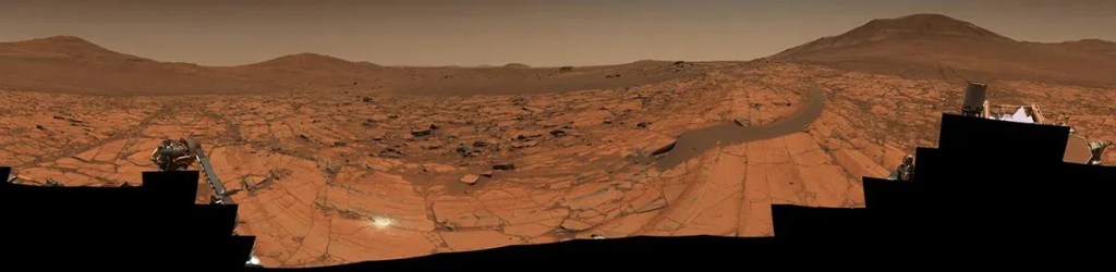
That enhancement is the key to understanding why Mars suddenly looks so Earth-like in this image. NASA released two versions of the panorama: the enhanced-color version that shows those striking blue skies, and a natural-color version that reveals Mars in its true rusty, reddish glory. The blue-sky version isn’t meant to deceive, but rather to help scientists distinguish between different geological features and atmospheric conditions by boosting color contrast.
It’s a reminder that Mars, despite its reputation as a dusty, hostile world, can occasionally surprise us with moments of startling clarity and beauty.
The Mystery of the Floating Rock
While the deceptively blue skies grab most of the attention, scientists are equally fascinated by a peculiar detail hiding in plain sight within the panorama: a large boulder that appears to be casually sitting on top of a dark, crescent-shaped sand ripple, as if someone just placed it there.
This isn’t your ordinary rock. Located about 14 feet from Perseverance, this mysterious boulder has geologists scratching their heads and reaching for a very specific term: “float rock.” It’s the kind of name that sounds like something from a fantasy novel, but in geological terms, it describes exactly what you’d think – a rock that doesn’t belong where it currently sits.
“Float rocks” are geological wanderers, formed in one location but somehow transported to where we find them today. Think of them as the ultimate hitchhikers of the geological world. But here’s where it gets interesting: nobody knows exactly how this particular rock made its journey to its current perch atop that sand ripple. Did it tumble down in a landslide? Was it carried by ancient Martian waters? Did fierce winds drag it across the landscape over millions of years?
The science team suspects this rocky traveler arrived at its current location before the sand ripple formed underneath it, creating this surreal scene that looks almost like someone carefully balanced the boulder there as part of some cosmic art installation.
Ancient Secrets Written in Stone
The Falbreen panorama isn’t just a pretty picture – it’s a geological treasure map revealing secrets that stretch back billions of years. About halfway up the image, eagle-eyed viewers can spot what looks like a subtle color change in the landscape, sweeping from one edge of the panorama to the other. This isn’t just a trick of lighting; it’s the boundary between two completely different geological units, each telling its own chapter in Mars’ ancient story.
The lighter-colored rocks closer to Perseverance are rich in olivine, a mineral that gives them their distinctive appearance. But those darker rocks in the distance? They’re believed to be much older clay-bearing formations, possibly some of the most ancient terrain Perseverance has ever explored. Some scientists think these rocks might even predate Jezero Crater itself, making them geological time capsules from Mars’ earliest days.
It’s like finding different chapters of a book written in stone, each layer revealing what Mars was like millions or even billions of years ago. The fact that Perseverance can capture these distinctions so clearly in a single panorama demonstrates just how far Mars exploration technology has advanced.
The Journey to Get Here
To understand why this panorama is so significant, you need to know just how far Perseverance has come – literally. The rover’s tire tracks are actually visible in the panorama, snaking away toward the right edge of the image like a breadcrumb trail showing its path through the Martian landscape. About 300 feet away, those tracks veer to the left and disappear from sight at a previous geological stop the science team calls “Kenmore.”
This isn’t just any random location Perseverance happened to roll up to. The rover reached the top of Jezero Crater’s rim late in 2024, marking a major milestone in its mission that began in February 2021. Getting to Falbreen required careful planning, precise navigation, and no small amount of engineering brilliance to guide a nuclear-powered robot across millions of miles of space and then across the challenging Martian terrain.
When Perseverance’s Mastcam-Z instrument captured these 96 images on Sol 1,516 (that’s Martian day 1,516, for those keeping track), it was doing more than just taking pictures. Each image represents a carefully planned scientific observation, with the rover’s operators on Earth coordinating the complex dance of positioning, timing, and technical settings needed to create this masterpiece.
More Than Just a Pretty Picture
While we’re all mesmerized by the stunning visuals, this panorama represents serious scientific work. That bright white circle visible just left of center near the bottom of the image? That’s not a rock or a piece of debris – it’s an abrasion patch, the 43rd rock Perseverance has deliberately scraped to reveal what lies beneath Mars’ weathered, dusty surface.
This particular patch, about two inches wide, was created on May 22, just four days before the panorama was captured. The rover used its drill to create this shallow exposure, allowing its arm-mounted instruments to perform what scientists call “proximity science” – detailed analysis of Martian rocks and soil composition.
The timing wasn’t coincidental. The science team specifically wanted to study the rocks at Falbreen because this location represents some of the oldest terrain they’ve encountered. By creating this abrasion patch and analyzing what they found, they’re essentially performing geology on rocks that could be older than anything previously studied by a Mars rover.
The Technology Behind the Magic
Creating a panorama like this on Mars isn’t as simple as pulling out your smartphone and hitting the panorama button. Every aspect of this image required careful planning and execution across millions of miles of space.
The Mastcam-Z instrument system that captured these images represents the cutting edge of planetary photography. Unlike a simple camera, Mastcam-Z is actually a sophisticated scientific instrument package that can capture images in multiple wavelengths of light, create detailed color analysis, and even perform 3D imaging of the Martian landscape.
The fact that the skies were unusually clear on Sol 1,516 was a stroke of luck that the imaging team didn’t waste. Mars’ atmosphere is notorious for dust storms that can last for months, turning the sky into a murky haze that makes long-distance photography nearly impossible. But on this particular day, conditions were perfect for capturing details as far as 40 miles away.
The process of stitching together 96 individual images into a seamless panorama is an engineering feat in itself. Each image had to be perfectly aligned, color-balanced, and processed to create the final mosaic that we see today. The enhanced-color version required additional processing to boost the contrast between different geological features, creating that striking blue-sky effect that makes Mars look so unexpectedly Earth-like.
What This Means for Future Mars Exploration
The success of capturing such detailed, long-distance imagery has implications that extend far beyond just creating stunning wallpapers for space enthusiasts. As acting NASA administrator Sean Duffy noted when the images were released, “Stunning vistas like that of Falbreen, captured by our Perseverance rover, are just a glimpse of what we’ll soon witness with our own eyes.”
This isn’t just space agency marketing speak. The detailed geological information captured in this panorama will help inform future mission planning, both for robotic explorers and eventual human missions to Mars. Understanding the terrain, geological composition, and atmospheric conditions at locations like Falbreen provides crucial data for selecting landing sites, planning traverses, and preparing for the challenges future Mars explorers will face.
The clarity and detail visible in this panorama also demonstrate how much Mars exploration technology has advanced since the early days of grainy, black-and-white images from NASA’s first Mars rovers. Today’s Mars explorers are equipped with scientific instruments that can analyze rock composition, study atmospheric conditions, and capture images that rival what professional photographers might achieve on Earth.
A New Perspective on the Red Planet
Perhaps most importantly, images like the Falbreen panorama are changing how we think about Mars itself. For decades, popular culture has portrayed Mars as a desolate, lifeless wasteland – the kind of place where you’d need a full spacesuit just to survive for a few minutes. While that’s certainly true from a human survival standpoint, these detailed images reveal a world of stunning natural beauty, complex geology, and fascinating scientific mysteries.
The mysterious float rock sitting atop its sand ripple, the clear delineation between different geological units, the surprising clarity of the atmosphere on a good day – all of these details paint a picture of Mars as a dynamic, complex world with its own unique character and beauty.
This shift in perspective matters because it affects how we approach future Mars exploration. Instead of viewing Mars as a hostile destination to be conquered, we’re beginning to see it as a fascinating world to be understood and appreciated. That change in mindset could influence everything from mission planning to public support for Mars exploration programs.
The Human Element in Robotic Exploration
Behind every stunning image from Mars stands a team of dedicated scientists, engineers, and mission planners working tirelessly to make these discoveries possible. The decision to capture the Falbreen panorama required coordination between multiple teams: mission planners who positioned the rover, imaging specialists who configured the camera settings, atmospheric scientists who recognized the perfect conditions, and data processing experts who assembled the final mosaic.
Jim Bell and his team at Arizona State University, who operate the Mastcam-Z instrument, represent just one part of this collaborative effort. The rover itself is managed by NASA’s Jet Propulsion Laboratory in California, with additional support from institutions across the country. It’s a reminder that even in our age of advanced robotics and artificial intelligence, human creativity, curiosity, and expertise remain at the heart of space exploration.
The Falbreen panorama stands as a testament to what’s possible when human ingenuity meets cutting-edge technology. It’s not just a beautiful image – it’s a window into another world, captured by a robot explorer that serves as an extension of human curiosity across the vast expanse of space.
As we continue to study the data from this remarkable panorama and plan future missions to Mars, one thing becomes clear: we’re just getting started in our exploration of the Red Planet. And if Mars can surprise us with clear skies and stunning vistas after decades of study, who knows what other wonders await discovery in the years to come?


